Strengthening the Surveillance System, ITS Professor Develops Unmanned NGC
Prof. Subchan SSi MSc PhD delivered his scientific oration regarding system optimization during his inauguration procession as the 162nd ITS Professor
ITS Campus ITS, ITS News – Current tensions between Russia and Ukraine require both parties to frequently utilize technology and Artificial Intelligence (AI) to carry out their missions. Inspired by this phenomenon, Professor from t15he Department of Mathematics, Institut Teknologi Sepuluh Nopember (ITS) Prof Subchan SSi MSc PhD conducted research related to Navigation, Guidance and Control (NGC) in unmanned systems to improve surveillance performance.
Through research which was used as his inauguration scientific oration as ITS’s 162nd Professor, Subchan said that the unmanned system he developed was strongly guided by NGC. He explained that navigation is the process of determining location, guidance acts as a guide to the path that must be followed, and control is an actuator to adjust the vehicle’s trajectory as desired. “Without NGC, aircraft and unmanned ground vehicles would not be able to operate properly,” said the doctoral alumnus of the Department of Aerospace Powers and Sensors, Cranfield University, England.
This man who was born in Jombang, May 13, 1971 explained that the unmanned system he developed had three stages of the process. The first is the process of identifying environmental conditions carried out by High-Level Unmanned Aerial Vehicles (UAV) and Unmanned Ground Vehicles (UGV), where this process is the beginning of identifying hazards in an area. “This stage is generally carried out to see temporary environmental conditions,” he explained.
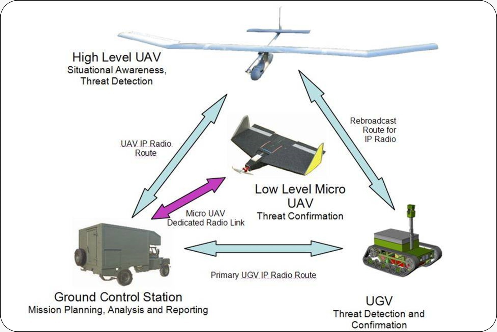
Illustration of an unmanned system developed by Prof. Subchan SSi MSc PhD, ITS Mathematics Professor
The next stage is confirmation of the situation by Low-Level Micro UAV and UGV. At this stage, the Micro UAV and UGV will receive a signal from the main UAV which directs it to take pictures and confirm the presence of danger in the area that has been created. After receiving the image, the third stage is the decision making stage, where the Ground Control Station (GCS) will review the data obtained from the UAV and UGV as a basis for decision making.
The Professor in the Department of Mathematics said that this research would support and speed up the monitoring and decision-making process at a surveillance stage. It was not only the unmanned concept that he emphasized, but this research has the potential to be utilized in the field of national defense technology. “With a robust route-taking system and automatic danger detection, the Indonesian military will be more efficient in protecting the homeland,” he said.
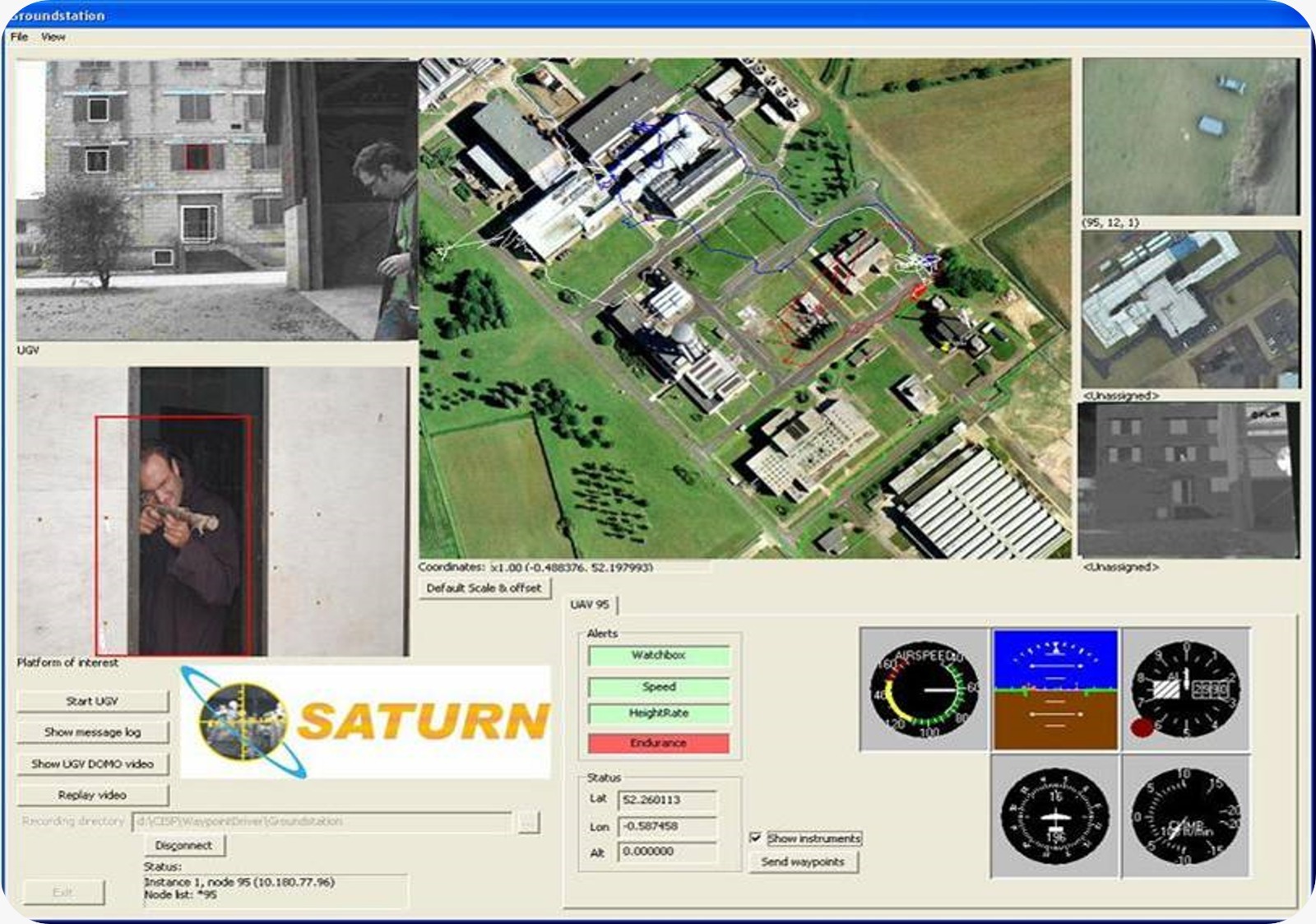
Screen illustration on a control system using NGC Unmanned Systems
In addition to high efficiency in unmanned systems, users of these systems will have accurate data information on the control system. According to Subchan, the control system he created is integrated with sensors in the field with the aim of making analysis easier. The data captured by the UAV and UGV has been well visualized through this system of unmanned NGC, so that tactical decisions can be made quickly.
With the birth of this research, Subchan hopes that Indonesia will be more responsive in facing dangers, both from land, sea and air. Not only military threats, he added that this research could be developed into other fields such as natural disaster management, natural disaster evacuation and other dangers. “I did this research as a form of my love for my homeland and the security of the Indonesian people,” he concluded. (ITS PR)
Reporter: Bima Surya Samudra
Translator: Nabila Aprilia Putri
Related News
-
ITS Supports Academic Infrastructure: New Medical Faculty Building
ITS Campus, ITS News — Entering the second year of accepting new students from the Faculty of Medicine and
August 31, 2023 13:08 -
ITS Welcomes 163 New Engineers to Empower Indonesia’s Growth
ITS Campus, ITS News – Institut Teknologi Sepuluh Nopember (ITS) continues its commitment to meeting the needs of engineers in
August 31, 2023 13:08 -
ITS Sends Off 12 Free Mudik Vehicles Ahead of Eid Al-Fitr
The dispatch of 11 bus fleets carrying ITS students for the Free Mudik ITS 2024 ITS Campus, ITS News
August 31, 2023 13:08 -
ITS Lecturer Wins 2024 Female Science Talents Intensive Tracks from Germany
Sri Fatmawati SSi MSc PhD, a lecturer at the Department of Chemistry, ITS, has emerged as the winner of
August 31, 2023 13:08