ITS Marine-Earth Science and Technology Research Center Develops Two New Industrial Services in Precision Geospatial Measurement
News


The Marine-Earth Science and Technology Research Center (STKK) at Institut Teknologi Sepuluh Nopember (ITS) has added two new industrial services to its 2026 performance record, both in the field of geospatial measurement and mapping. The services are led by Mokhamad Nur Cahyadi, S.T., M.Sc., Ph.D.
Precision Satellite Measurement System (GNSS)
The first service is the development of a precision satellite measurement system based on Global Navigation Satellite Systems (GNSS). This technology uses signals from navigation satellites to determine positions on the ground with high accuracy, and is widely used in land surveying, construction, infrastructure monitoring, and coastal and marine mapping.
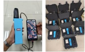
Mobile Laser Scanning System (Mobile Mapping LiDAR)
The second service is the development of a mobile laser scanning system, known as mobile mapping LiDAR. Mounted on a moving platform, laser scanners capture millions of measurement points of the surroundings, producing detailed three-dimensional models of roads, buildings, and terrain much faster than conventional surveys.
Together, the two services extend the center’s capacity to support industry and infrastructure projects that need accurate, up-to-date spatial data, an area of growing importance for coastal management and disaster risk reduction in Indonesia.
Latest News
-
ITS Surabaya to Host 7th International Conference on Coastal Sustainability and Resilience on 26 November
Surabaya – Institut Teknologi Sepuluh Nopember (ITS) will host the 7th Sustainability and Resilience of Coastal Management (SRCM) conference
-
STKK ITS Secures National Funding to Develop Motorcycle LiDAR Prototype for Regional Asset Monitoring
Surabaya – The Center for Marine-Earth Science and Technology Research (STKK) at the Sepuluh Nopember Institute of Technology (ITS)
-
ITS Marine-Earth Research Center Records Four Prototypes in Early 2026, From Floating Solar to LiDAR Mapping
Surabaya – The Center for Marine-Earth Science and Technology Research (STKK) at ITS recorded four prototype products in its