ITS Campus, ITS News-the phenomenon of rising sea level can be a serious problem in the future, considering Indonesia is dominated by ramps and vast coastal areas. Seeing this, Institut Teknologi Sepuluh Nopember (ITS) lecturer, Dr. Eko Yuli Handoko ST MT, researched vulnerability analysis of North Coast areas of Java as the impact of sea-level rising.
Explained by Eko, the dominant sea level raising is caused by the rising temperature at sea level and the melting of ice in glacial and polar ice, which contribute to climate change. Also, rising sea levels can be caused by plate movement. “The location of Indonesia is between the Pacific Ocean and the Indies, it can cause a variety of raising sea-level or commonly known as El Niño phenomenon,” he explained.
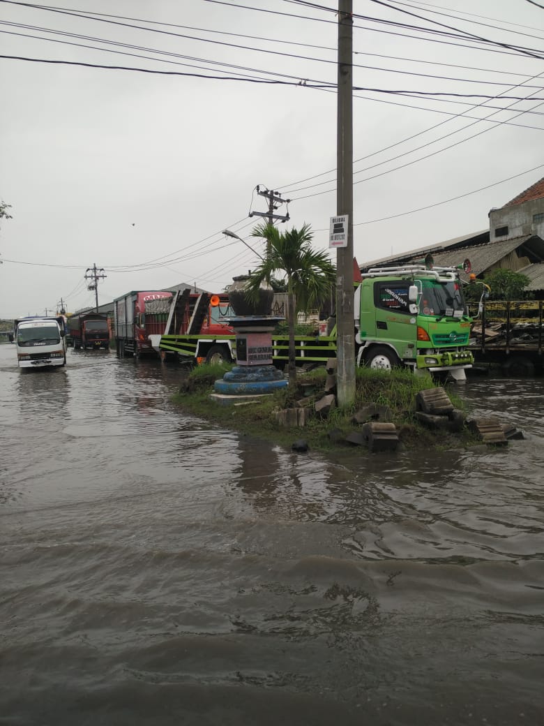
Intergovernmental Panel on Climate Change (IPCC) has projected that the rising sea level can reach 44 to 47 centimeters (cm). “The predictions are very important for us because it can make a significant negative impact in the future, give the many activities of Indonesian society and the socio-economic activities on the coast,” said this lecturer of the Departement of geomatics engineering. The impact can be floods that caused by seawater (Rob) and seawater intrusion into the surface water and aquifer.
Eko with his colleagues took the North Coastal area of Java, especially Semarang, and Demak to be analyzed. It reveals the big cities in Java Island are usually located on the north coast such as Jakarta, Pekalongan, Semarang, Tuban, and Surabaya. “Generally the big city on the north Java has decreased ground surface, so the more vulnerable to the influence of rising of sea level,” said Eko.
In general, Eko continued, rising of sea level in the region of Indonesia ranges from 2 to 10 millimeters (mm) annually. “On the Northcoast of Java Island, the ascent reaches 5 mm per year,” he added.
In this study, Eko said, the method used to analyze the vulnerability of coastal regions used the Coastal Vulnerability Index (CVI) algorithm. In CVI there are several important parameters used to determine the index, such as geomorphology, elevation, coastline change, tides, wave height, and rising of sea level
“After entering the value of CVI vulnerability, three-dimensional (3D, red)-related modeling may be affected in the next 100 years if no significant handling was taken by Semarang Government,” reminds Eko.
Eko explained again, the data of sea-level increase was obtained by processing data from Altimetri Multi Missions satellite, namely Topex/Poseidon, Jason-1, and Jason-2. “Data were taken from the initial period of 1993 to the end of the year 2016 or approximately 23 years,” he said. Altimetry data calculation is done after performing distance correction and geophysical, then the inter-calibration on each mission to maintain continuity. Its analysis is calculated using Seasonal models Trend decomposition based on LOESS (STL), and linear trend using Original Linear Square (OLS) fittings.
From the results of the study, with the initial conditions of land use predicted that 100 years, 11,380 hectares of the flooded area, where 9,127 hectares is building area with a loss of Rp 313 billion. “Existing conditions on the coast of Semarang shows that the rise of the sea level is higher than the land surface, so that seawater floods in land, either directly or through the flow of the river,” explained Eko.
The flooded area, according to Eko, has a very dense awakened land when compared to the higher areas. But in fact, the existing Regional Spatial Plan (RTRW) of Semarang has not accommodated existing vulnerabilities. So many building that serves warehousing, trading, and services even the airport is predicted in a very vulnerable area. “With the results of this study, I hope it can be an input to the local government to prepare disaster mitigation for the vulnerability of coastal areas,” said Eko
So far, said Eko, the city government has also carried out the preparation and anticipation of disasters, such as the development and revitalization of river and flood channels, as well as making pump houses on streams and territories that flood potential. “Government support through local regulations and regional planning is necessary, but it is not less important than the socialization of the local government to its citizens to protect the environment,” said Eko. (meg/rev/ITS Public Relations)