ITS Expert Gives a Review and Recommendation regarding the Semeru Eruption
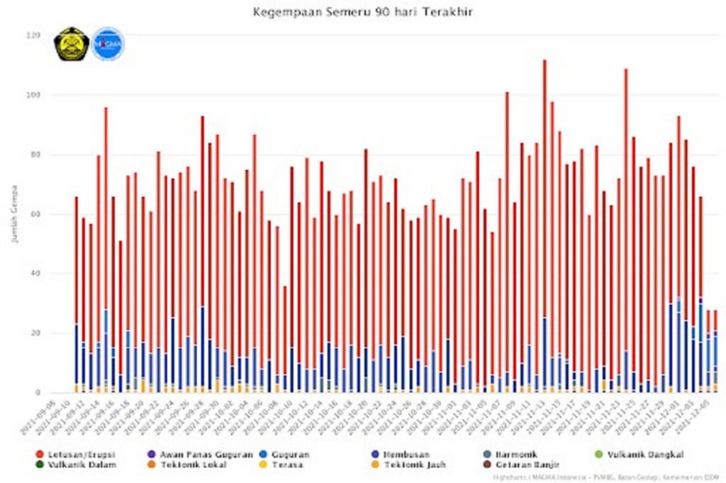
The Semeru volcano seismic data in the last 90 days (Source from https://magma.esdm.go.id/ )
ITS Campus, ITS News –The Mt. Semeru Eruption on December 4th affected several surrounding villages. The effects the scattered volcanic material and lives lost. Responding to this catastrophic event, a geologist from Institut Teknologi Sepuluh Nopember (ITS) M Haris Miftakhul Fajar MEng revealed that most of the material avalanches were accumulated from the eruptions of the previous days.
A volcanic eruption is a natural process related to endogenic processes and is caused by the instability of the magma chamber. According to this lecturer at the Department of Geophysics Engineering, the recorded seismic activity of Mount Semeru at that time did not show an earthquake because of the enormous eruption. However, seismicity data was recorded due to the sharp increase in avalanche activity and small-intensity eruptive earthquakes.
When referring to data from the Center for Volcanology and Geological Hazard Mitigation (PVMBG) of the Ministry of Energy and Mineral Resources (KESDM), since last November, there has been an increase in volcanic activity in the form of an earthquake with the eruption of Mount Semeru. “So, along with an increase in eruptive activity, it is also indicated that there is an increase in the amount of volcanic material that has accumulated around the crater,” said Haris.
The accumulation of the amount of material in the hood of Mount Semeru causes the peak to be higher. On the other hand, slope instability also increases. “Moreover, the eruption material released by Mount Semeru is still unconsolidated volcanic material,” he explained. The material characteristics are very easily eroded and can lead to collapse.
The extreme weather at the end of 2021 helped push the erosion process to increase. As a result, amid heavy rain last Saturday (4/12), volcanic material avalanches had a massive impact on several Mount Semeru. This can be seen from the ash rain accompanied by Awan Panas Guguran (APG) or hot clouds avalanches.
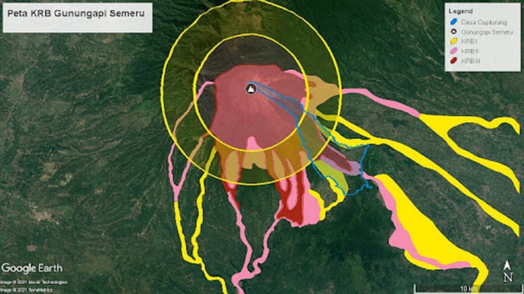
Map of Mount Semeru Disaster-Prone Areas by PVMBG
On the other hand, people tend not to feel the vibrations of the Mount Semeru eruption when this event occurs. “When the collapse occurs, it is accompanied by vibrations. However, the magnitude of the vibration is small, so the residents don’t feel it,” said the lecturer, who was born in 1989. However, these vibrations can be captured by seismographs as avalanche seismicity.
Meanwhile, seismograph data also succeeded in detecting seismicity due to the eruption at 14.50 WIB on the same day with a maximum amplitude of 25 mm and a duration of 5,160 seconds. From there, it is indicated that an eruption occurred immediately after the fall of volcanic material due to reduced pressure in the upper layer of Mount Semeru. “This eruption occurred on a small scale, with seismic vibrations not being felt by residents,” he said.
Although most of the collapsed material comes from deposits of volcanic material from previous eruptions and not material that has just come out due to a large eruption, the material still retains heat at high temperatures. “The heat is still there because of the thickness of the massive material deposits,” said the lecturer, who likes to climb mountains.
In addition, he continued, from the very beginning, the material came out of the bowels of the earth, the heat reached a very high temperature, which was around 300-700 degrees Celsius. So, when the volcanic material deposits collapse, the accompanying hot clouds are about 200-400 degrees Celsius, and there is also hot rain lava.
M Haris Miftakhul Fajar MEng, lecturer, and researcher at the Department of Geophysical Engineering ITS
Overview of Mount Semeru
Uniquely, Mount Semeru is a volcano that usually emits gas and volcanic material every 30-60 minutes, with small-intensity eruptions. This distinguishes Mount Semeru from other volcanoes, such as Mount Merapi or Mount Kelud. “Semeru rarely erupts on a large scale because it regularly channels pressure and volcanic material from the magma chamber to the earth’s surface,” explained Haris.
This, according to Haris, can be an advantage because we can slightly avoid the accumulation of immense pressure in the magma chamber. The eruption that occurred on Mount Semeru after the volcanic eruption occurred and the pressure on the cover was reduced is still ongoing in small-scale eruptions. This shows that the pressure and material in the magma chamber of Mount Semeru are not too enormous.
On the other hand, the lecturer from Blitar added, we must also watch out for this character because the eruption material only collects around the peak area. “At any time, landslides will easily occur if they have reached the limit of slope instability,” he added. Mount Semeru is at an alert level because the volcanic activity does not show a significant increase, which indicates a large eruption.
M Haris Miftakhul Fajar MEng, lecturer, and researcher at the Department of Geophysical Engineering ITS
Recommendation
According to Haris, such volcanic activity is a cycle. Due to the laws of nature, these activities are bound to repeat themselves. “But there is no need to panic, and you must remain vigilant, realizing that Mount Semeru is currently carrying out its routine,” he ordered. So, we should share time and space in harmony with it.
Haris also reminded all parties to comply with the Mount Semeru disaster-prone area (KRB) that PVMBG had made. Based on the map, we can see that one of the areas most impacted and potentially experiencing the most massive damage is Cupiturang Village. “In an area like that, if the disaster still occurs after the warning, it certainly adds to our concerns,” he said.
Therefore, this should be used as a lesson that it is essential that spatial planning is also based on the KRB Map. In addition, to the community and volunteers working in the current evacuation process, he also reminded them always to be aware of the possibility of further avalanches of volcanic material.
It is necessary to immediately observe the condition of material deposits when the weather is favorable, and the view is clear of fog. “Also, be aware of the potential for further eruptions due to the reduced cover layer that resists pressure,” he reminded again. (ITS Public Relations)
Reporter: Kafa ‘Aisyana Ni’mah
Related News
-
ITS Rises to Second Rank in Most National PKM Funding
ITS Campus, ITS News – Strengthening its determination in the scientific field, the Institut Teknologi Sepuluh Nopember (ITS) succeeded
December 08, 2021 16:12 -
Examining Kenny, the Best ITS Bachelor Graduate with a GPA of 3.94
ITS Campus, ITS News — Educating for 3.5 years at the Institut Teknologi Sepuluh Nopember (ITS) did not prevent Benedictus
December 08, 2021 16:12 -
Inspirational, Deaf ITS Graduates Graduated with Cumlaude Predicate
ITS Campus, ITS News — An inspiring story was also present at the 129th Graduation Ceremony of the Institut Teknologi
December 08, 2021 16:12 -
129th Graduation: ITS Graduates 1,355 Candidate Leaders
ITS Campus, ITS News – Institut Teknologi Sepuluh Nopember (ITS) again held a graduation procession for its students through the
December 08, 2021 16:12