ITS Expert Response on Earthquake and Tsunami in East Java by BMKG

Dr. Ir Amien Widodo MSi, a geologist from the Center for Disaster Mitigation and Climate Change Research (MKPI) opened his opinion for BMKG
ITS Campus, ITS News – Late last month, the Meteorology, Climatology and Geophysics Agency (BMKG) announced the results of mathematical modeling conducted to predict the strongest and largest earthquake and tsunami that may hit East Java. As a result, the earthquake that could potentially shake East Java is as strong as magnitude (M) 8.7 and very likely followed by a tsunami as high as 29 meters maximum.
Seeing this, Dr. Ir Amien Widodo MSi, geologist of Institut Teknologi Sepuluh Nopember (ITS) also opened his voice in response. According to him, modeling done by BMKG is the right first step. Considering that East Java formed due to the collision of the Eurasian and Indo-Australian plates, it became a necessity to examine the earthquake chapter in East Java. The reason is BMKG is not without reason mention the worst-case scenario that may befall.
“This modeling shows the worst scenario then announced because in the last five months. It knows that the frequency of earthquakes that occur in East Java is very high,” said the lecturer of the Department of Geophysical Engineering. The high intensity of this earthquake should be suspected, learning from the great earthquake in Jogja on May 27, 2006.
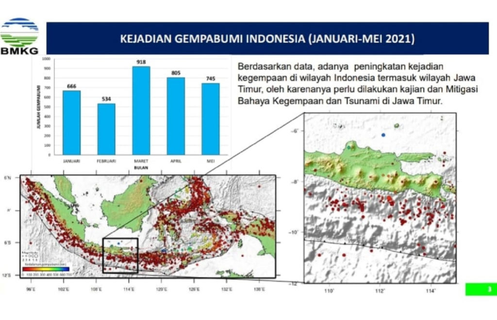
Graph of earthquake events in Indonesia by the Meteorological Agency of Climatology and Geophysics (BMKG) in 2021 shows the high number of earthquake events.
One of the signs, before the Jogja earthquake, was recorded increasingly frequent earthquake activity. At that time, the frequency of earthquakes increased, but not more than 50 earthquakes each month. “Meanwhile, in the last five months, the earthquake recorded always more than 500 events per month,” explained Amien.
It’s a very different frequency in 2006 than it is today. Therefore, it is appropriate that we are much more vigilant. What’s more, added Amien, the collision of plates that make up East Java is about 250 to 300 kilometers to the shoreline. This indicates that earthquakes are very likely to occur at various points, in the area around the subduction zone, which is the zone where the collision occurred.
Observation of earthquake activity is also based on measurable seismic data. In addition to referring to the history of earthquakes. Although according to research seismic activity recorded so far is uneven, but according to Amien, it is precise that that needs attention. “If the intensity of the earthquake at each point of the subduction zone is the same, but found a zone with a seismic gap, it means that there is a possibility that the slab is locked and will come off at any time,” he said.
In Indonesia, zones with seismic gaps mark in nine regions from Sabang to Merauke. One of them is in East Java, close to Bali. If the area that is estimated to be experiencing inter-glued locking eventually comes off and causes a large earthquake. It calculates that there will be 20 to 25 minutes for the water to reach land considering the distance of the subduction zone from the shoreline.
Graph of earthquake events in Indonesia by the Meteorological Agency of Climatology and Geophysics (BMKG) in 2021 shows a high number of earthquake events
“Not to mention, if the earthquake that occurred with a magnitude of M 8.7, will push the faults in East Java so that it is activated,” he added. Activated faults will be able to cause other earthquakes caused by dislocation. Meanwhile, the faults pass through densely populated areas, such as Banyuwangi, Probolinggo, Pasuruan, and Surabaya.
Although, It is of little power. If it occurs in an urban area it will be just as dangerous. Amien asserts that earthquakes do not kill, but can trigger liquefaction, amplification, landslides, and tsunamis, as well as damage to infrastructure. Historically, the worst liquidation in East Java has occurred in Lumajang. Therefore, It emphasizes Amien. So that the public knows the kinds of disasters and mitigations.
Not only earthquakes but also tsunami predictions with an altitude of 29 meters, It should be known earlier. Amien opened the record of earthquake and tsunami that had hit East Java, also mentioned that exactly today (3/6) in 1994, there was an earthquake as strong as M 7.8 and caused a tsunami as high as 14 meters in Pancer, Banyuwangi.
In addition, in the tsunami catalog, BMKG recorded that the tsunami had hit the south coast of East Java three times in previous years. With the water travel time to get to the land as mentioned earlier, that is for 20 to 25 minutes. So if there is a tsunami sign there are only about 20 minutes for coastal residents to go to higher ground, at least as high as 20 meters.
“It is important that education is related to mitigation known as 20-20-20,” he warned. That is so that if the earthquake is felt for 20 seconds, without the need to wait for the water to recede. Immediately go to a place with a minimum height of 20 m because the time is only about 20 minutes.

Verified Tsunami Hazard Map, general forecast of the height and time of arrival of tsunami worst-case scenario in East Java Province
This education chapter, which according to Amien also underlies BMKG to break this news now. Evaluation of the Malang earthquake some time ago, with the scale of the earthquake strength of M 6 alone brings a considerable impact of the damage. “We must be more vigilant if East Java has the potential to experience earthquakes up to the strength of M 8.7,” he said.
Researchers from ITS Center for Disaster Mitigation and Climate Change Mitigation (MKPI) then advised. So that the community does not feel panic and anxiety, but adds to the prudence by preparing earthquake-worthy infrastructure and other education. “No exception the government should seek socialization related to mitigation, not only in disaster-prone category areas, but the entire region,” he said.
In the end, Amien invites people to reflect on the tragedy of the great earthquake in Japan. According to the research survey, of the total survivors, 35 percent of the people have disaster insights, another 32 percent have similarly insightful families, while another 28 percent are neighbors with people with knowledge about disasters.
If education related to disasters and mitigation is carried out, from Amien’s view, there will be a great opportunity to reduce the number of fatalities due to hydrometeorological disasters such as earthquakes and tsunamis. “While equipping the area with evacuation routes, we must be willing to educate ourselves to be ready to be prepared for mitigation when disasters occur,” his message concluded. (ITS PUBLIC RELATIONS)
Reporter: Kafa ‘Aisyana Ni’mah
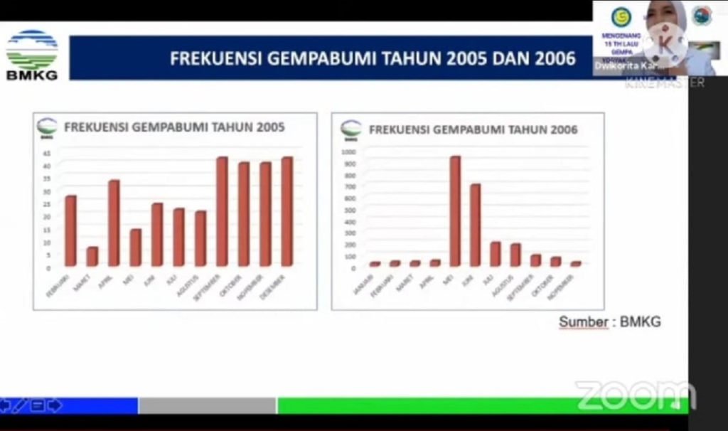
Graph of the 2005 and 2006 earthquake catalogs, footage of earthquake events shortly with the occurrence of a major earthquake in Jogja on May 27, 2005, that was once described by BMKG head Dwikorita Karnawati
Related News
-
Supporting the Development of Material Processes, ITS Professors Utilize Biomass Waste
ITS Campus, ITS News — Innovation in material processes continues to develop to support society’s need for environmentally friendly
June 03, 2021 20:06 -
ITS Professor Ideas for Bio-Corrosion Control in Marine Structures
ITS Campus, ITS News — Coastal and offshore buildings interacting directly with seawater trigger damage, including bio-corrosion. If not
June 03, 2021 20:06 -
ITS Launches the First Marine Floating Solar Power Plant Prototype in Indonesia
ITS Campus, ITS News — Institut Teknologi Sepuluh Nopember (ITS)‘s commitment in realizing the energy transition is getting serious.
June 03, 2021 20:06 -
Targeting Champion, Bayucaraka ITS Launches Flying Robot Innovation
ITS Campus, ITS News – The Bayucaraka team at Institut Teknologi Sepuluh Nopember (ITS) has launched four new flying
June 03, 2021 20:06