Offer Solutions to Overcome Landslides, ITS Student Paper Published Internationally
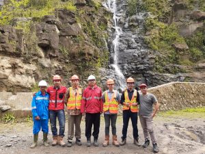 ITS team along with partners from Medco Power Indonesia Company, in the middle of conducting field surveys
ITS Campus, ITS News – Starting from its concern for the possibility of landslides that befell the community in an area, Institut Teknologi Sepuluh Nopember (ITS) Geophysical Engineering Department students make a scientific paper that discusses the importance of the geophysical approach in disaster management. Through five integrated geophysical methods, the landslide experienced has become easier to solve.
Frankstein Arphan, Gregorio Adri Prawira, Darrian Alisantoso along with a student from the Physics Engineering Department, Tita Oxa Anggrea, started their research when Medco Power’s company power plant continued to experience land subsidence and landslides. In fact, after an experiment to solve the problem, landslides never stop happening.
Previously, the company had tried to move the water flow line to the power plant as an attempt to solve it. However, after reviewing, it seems that further research is needed to be done in the field of landslides in the power plant area.
In cooperation with the Medco Power Company, the ITS team was met with Sugiyono and Pramadi, from the company, to conduct joint research. Frankstein said, with his team, he offered a solution by integrating five geophysical methods at once, namely Very Low Frequency (VLF), Electrical Resistivity Tomography (ERT), Vertical Electrical Sounding (VES), Remote Sensing, and Sondir.
“The remote sensing method is used to obtain topographical data of an area,” Frankstein explained. Data obtained from ERT provides an overview of a two-dimensional subsection of the surface. While data obtained from the VES is mapping subsurface in one dimension, such as showing the drilling holes. The integration of ERT and VES data will create a three-dimensional image of the underground surface that can be used as a reference to detect boundary layers.
“The result is validated to provide predictive lithology of measurement results using the Sondir method,” he explained.
Associated with real-time drilling data, the drill results turned out to indicate the presence of weak zones caused by an irrigation pipe leakage. As a result, the layer is easy to be shifted because of the characteristic of the layer that saturated to the water in the weak zone.
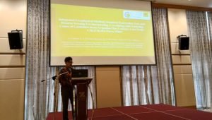 Gregorio Adri Prawira when began his paper presentation at the Regional Conference on 2019 Natural Disaster in Malaysia
Meanwhile, Darrian Alisantoso said, apart from pipe leakage, after conducting the subsurface analysis, it was found that many springs continued flow fast, even during the long dry season. “It then led our team to conclude, many sedimentations was saturated by the presence of water there,” he said.
From the research that has been done, the company can obtain a reference to the boundary fields found to be implemented in overcoming the potential for landslides. Thanks to this cooperation research, three papers were successfully written as the work of ITS students who reached the international arena in the 7th AUN/SEED-Net Regional Conference on 2019 Natural Disaster in Malaysia, on 25 – 26 November.
All of the papers discussed the geophysical methods that can map the subsurface structures in three-dimensional, resulting in the form of landslide areas as an effort to prevent landslides. The three research papers were also successfully published in the IOP Conference Series: Earth and Environmental Science (EES) or the ASEAN Engineering Journal (AEJ), which has been indexed by Scopus.
The team guided by Dr. Dwa Desa Warnana SSi MSi expressed their gratitude to PT PLN and Pupuk Kaltim who have been involved in this research and publication. “For the support of these parties, we succeeded to publish our three papers,” Frankstein said. (qaf/gayatri/ITS Public Relations)
Related News
-
ITS Rises to Second Rank in Most National PKM Funding
ITS Campus, ITS News – Strengthening its determination in the scientific field, the Institut Teknologi Sepuluh Nopember (ITS) succeeded
January 22, 2020 18:01 -
Examining Kenny, the Best ITS Bachelor Graduate with a GPA of 3.94
ITS Campus, ITS News — Educating for 3.5 years at the Institut Teknologi Sepuluh Nopember (ITS) did not prevent Benedictus
January 22, 2020 18:01 -
Inspirational, Deaf ITS Graduates Graduated with Cumlaude Predicate
ITS Campus, ITS News — An inspiring story was also present at the 129th Graduation Ceremony of the Institut Teknologi
January 22, 2020 18:01 -
129th Graduation: ITS Graduates 1,355 Candidate Leaders
ITS Campus, ITS News – Institut Teknologi Sepuluh Nopember (ITS) again held a graduation procession for its students through the
January 22, 2020 18:01